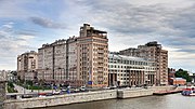
Island (Zamoskvorechye)
Island is an area in Moscow. It is made up of an artificial island and is located right across from the Kremlin between the Moskva River and its old riverbed, which was turned into the Vodootvodny Canal in 1786. It does not have any historical, official or established name. In the relevant sources it is referred to simply as the Island.
Read article
Top Questions
AI generatedMore questions
Nearby Places

Tretyakov Gallery
Art museum in Moscow, Russia

Bolshoy Kamenny Bridge

House on the Embankment
Apartment building in Moscow, Russia
Children Are the Victims of Adult Vices
Sculpture by Mihail Chemiakin

Kadashi Church
Russian International Affairs Council
Pro-Russian think tank

House of Lobkov on the Sophia Embankment
Building in Sofiyskaya naberezhnaya, house

GES-2 (Moscow)
Decommissioned Russian power station


